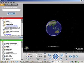
Let’s said for famous place like Japan, Singapore.......No problem.....you can zoom into that deepest level. If you just like me who staying in Malaysia, then too bad! You only allowed zooming into the "State" zoom. Which mean it is not in "Detail and high" resolution; anyway.......it is still nice to see the scenery from top view.
Here are some examples of the screen shots:

This is the most Top view - An earth (of course it is just one la!!)

Malaysia Map

Malaysia Map- Zoom in further

Malaysia Map - Zoom in more further (Note:Cannot go into more deep)

The bridge that connect between Malaysia and Singapore

The most deep level it can goes...Into Singapore (This zoom level not available for malaysia yet!)
Where to download it? http://earth.google.com
If you wanna get a pro version, you might get it from me if you see me online and when I am in free, haha!

8 comments:
Somehow it reminds me of sim city or theme hospital , haha...those building games. it would be scary if they could zoom downt o people level
ya......it might be looks like sim city......but this one is REAL one...u know? although it is not REAL time la.
feels funny when one day you zoom to the lowest level and meet someone familiar, and then you call them up and say..
"Hey...I'm looking at you now. Look up in the sky...!!!"
if like tat, dun u feel so dangerous. Even your parents able to detect your location. If you bluff at it, they said....."We c u from the sky"!!!! haha!
eh.. how is PRO version? :P
If can zoom until street in Malaysia then good la.. but too bad... MAlaysia not famous enough for them :(
it'll be a nice and useful when you're lost on the roads and that you have an internet-enabled PDA. can be used to avoid the jam as well.....
haha! but the system is not real time!! As what I know, the pictures that uploaded in the system must update within "3 Years", which mean.....A building destroyed now, it might take 3 years to renew the picture...it isnt so good la....
unless we see who going to sponser a satelite to us, then we can Spot CHECK what other peoples doing anytime....haha!
Eng end?...u lost on the road? i got a 600pages detail klang valley map book here. It would be almost imposible to get ur self lost with that book.
Post a Comment